The geological features of this region offer the prospect of finding signs of past life
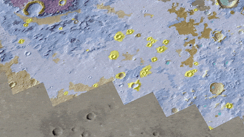
A group of European scientists has published the most detailed geological map of Oxia Planum — landing site of the European Space Agency (ESA) rover «Rosalind Franklin» to Mars. This instrument will allow the rover to explore the once water-rich terrain and discover signs of past life.
The map gave scientists a head start in preparation for the rover's landing on Mars in 2030. Over four years of work, this map has identified 15 features with distinctive geological features that will help determine strategies for exploring the area, interpreting data, and collecting evidence of former life.
Oxia Planum is located near the Martian equator and consists of sedimentary deposits that are about four billion years old. On a geological scale, this will be the oldest landing site the rover will visit. The area is rich in clay minerals that were formed in the presence of water. Their research is well suited to finding evidence of ancient life forms.
During the quarantine caused by the COVID-19 pandemic, scientists from the group of «Rosalind Franklin» developed an online program for 80 volunteers to help map selected landing sites. The work was divided into 134 one-square-kilometer sections to completely cover the rover's future landing zone. Participants used a web-based system provided by NASA's Jet Propulsion Laboratory and hosted by ESA.
The map was created using data from NASA's ExoMars Trace Gas Orbiter and Mars Reconnaissance Orbiter (MRO), including the HiRISE camera, which provides images with a resolution of 25 centimeters per pixel. Project leaders compiled information from all areas to create a coherent map that illuminates the geology of the area in unparalleled detail. The map shows the main rock types and various structures such as ridges and craters. She also points to various materials such as discarded meteorite fragments.
The result of the work was the Oxia Planum map with an incredibly high resolution on a scale of 1:25,000, where each centimeter on the map is equal to 250 meters on the surface of Mars. The middle route of «Rosalind Franklin» 25 to 50 meters per day will be shown at a scale of one to two millimeters on the map.
In creating the map, scientists from different groups carefully studied the geology and geography of the landing site long before the rover set off for Mars. The science team now has a clearer understanding of the objectives, the type of terrain the rover will encounter, and the dangers it will face.
«This map serves as a visual hypothesis for us, showing what questions we can find answers to. She will be our guide, where we can test our knowledge on the spot using the rover's instruments», — explains Peter Fawdon, one of the study's lead authors from the Open University.
The Rosalind Franklin rover, developed by the European Space Agency, is equipped with drilling and scientific instruments to detect traces of past and present life on Mars. The map will allow scientific teams on Earth to develop a strategy for daily Martian expeditions, identifying the best places for drilling in the harsh radiation environment and temperature fluctuations on the planet's surface.
«Rosalind Franklin» will be the first rover to be able to drill down two meters, collecting samples where biological markers are more likely to be preserved than on the surface, and analyze them in its onboard laboratory. This will significantly expand the possibilities of Mars exploration.

